


Voting Districts not defined, St. Mary's County, Maryland
About
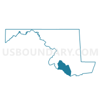
Outline

Summary
| Unique Area Identifier | 593118 |
| Name | Voting Districts not defined |
| County | St. Mary's County |
| State | Maryland |
| Area (square miles) | 397.53 |
| Land Area (square miles) | 0.10 |
| Water Area (square miles) | 397.43 |
| % of Land Area | 0.03 |
| % of Water Area | 99.97 |
| Latitude of the Internal Point | 38.12844050 |
| Longtitude of the Internal Point | -76.49052300 |
Maps


Graphs
Select a template below for downloading or customizing gragh for Voting Districts not defined, St. Mary's County, Maryland


Neighbors
Neighoring Voting District (by Name) Neighboring Voting District on the Map
- Voting District 1a, Northumberland County, VA
- Voting District 2a, Northumberland County, VA
- Voting District 5a, Northumberland County, VA
- Charles Precinct 09-002, Charles County, MD
- Dorchester Precinct 06-001, Dorchester County, MD
- Dorchester Precinct 10-001, Dorchester County, MD
- Precinct 1-1, Westmoreland County, VA
- Precinct 2-1, Westmoreland County, VA
- Precinct 3-1, Westmoreland County, VA
- St. Mary's Precinct 01-001, St. Mary's County, MD
- St. Mary's Precinct 01-002, St. Mary's County, MD
- St. Mary's Precinct 02-001, St. Mary's County, MD
- St. Mary's Precinct 02-002, St. Mary's County, MD
- St. Mary's Precinct 03-001, St. Mary's County, MD
- St. Mary's Precinct 03-002, St. Mary's County, MD
- St. Mary's Precinct 03-003, St. Mary's County, MD
- St. Mary's Precinct 03-004, St. Mary's County, MD
- St. Mary's Precinct 04-003, St. Mary's County, MD
- St. Mary's Precinct 05-002, St. Mary's County, MD
- St. Mary's Precinct 05-003, St. Mary's County, MD
- St. Mary's Precinct 06-001, St. Mary's County, MD
- St. Mary's Precinct 06-002, St. Mary's County, MD
- St. Mary's Precinct 06-003, St. Mary's County, MD
- St. Mary's Precinct 07-001, St. Mary's County, MD
- St. Mary's Precinct 08-001, St. Mary's County, MD
- St. Mary's Precinct 08-002, St. Mary's County, MD
- St. Mary's Precinct 08-004, St. Mary's County, MD
- St. Mary's Precinct 08-006, St. Mary's County, MD
- St. Mary's Precinct 09-001, St. Mary's County, MD
- Voting Districts not defined, Somerset County, MD
- Voting Districts not defined, Calvert County, MD
- Voting Districts not defined, Charles County, MD
Top 10 Neighboring County Subdivision (by Population) Neighboring County Subdivision on the Map
- District 8, Bay, St. Mary's County, MD (37,832)
- District 2, Prince Frederick, Calvert County, MD (30,135)
- District 1, Solomons Island, Calvert County, MD (28,845)
- District 3, Leonardtown, St. Mary's County, MD (15,403)
- District 6, Patuxent, St. Mary's County, MD (12,193)
- District 5, Mechanicsville, St. Mary's County, MD (12,061)
- District 4, Chaptico, St. Mary's County, MD (10,180)
- Washington district, Westmoreland County, VA (8,916)
- District 1, St. Inigoes, St. Mary's County, MD (7,077)
- District 2, Valley Lee, St. Mary's County, MD (6,834)
Top 10 Neighboring Place (by Population) Neighboring Place on the Map
- California CDP, MD (11,857)
- Lexington Park CDP, MD (11,626)
- Golden Beach CDP, MD (3,796)
- Leonardtown town, MD (2,930)
- Piney Point CDP, MD (864)
- Tall Timbers CDP, MD (462)
- St. George Island CDP, MD (257)
Top 10 Neighboring Unified School District (by Population) Neighboring Unified School District on the Map
- Charles County Public Schools, MD (146,551)
- St. Marys County Public Schools, MD (105,151)
- Calvert County Public Schools, MD (88,737)
- Dorchester County Public Schools, MD (32,618)
- Somerset County Public Schools, MD (26,470)
- Westmoreland County Public Schools, VA (13,956)
- Northumberland County Public Schools, VA (12,330)
Top 10 Neighboring State Legislative District Lower Chamber (by Population) Neighboring State Legislative District Lower Chamber on the Map
- State House District 99, VA (80,416)
- State Legislative Subdistrict 29B, MD (53,439)
- State Legislative Subdistrict 29A, MD (46,007)
- State Legislative Subdistrict 29C, MD (42,041)
- State House Districts not defined (Calvert County), MD (0)
- State House Districts not defined (St. Mary's County), MD (0)
- State House Districts not defined (Dorchester County), MD (0)
- State House Districts not defined (Somerset County), MD (0)
- State House Districts not defined (Charles County), MD (0)
Top 10 Neighboring State Legislative District Upper Chamber (by Population) Neighboring State Legislative District Upper Chamber on the Map
- State Senate District 28, VA (223,256)
- State Senate District 29, MD (141,487)
- State Senate Districts not defined (Charles County), MD (0)
- State Senate Districts not defined (Calvert County), MD (0)
- State Senate Districts not defined (St. Mary's County), MD (0)
- State Senate Districts not defined (Dorchester County), MD (0)
- State Senate Districts not defined (Somerset County), MD (0)
Top 10 Neighboring 111th Congressional District (by Population) Neighboring 111th Congressional District on the Map
Top 10 Neighboring Census Tract (by Population) Neighboring Census Tract on the Map
- Census Tract 8514, Charles County, MD (8,176)
- Census Tract 8609, Calvert County, MD (7,693)
- Census Tract 8759.02, St. Mary's County, MD (7,638)
- Census Tract 8761, St. Mary's County, MD (7,560)
- Census Tract 8757, St. Mary's County, MD (7,470)
- Census Tract 8759.01, St. Mary's County, MD (7,280)
- Census Tract 8762, St. Mary's County, MD (7,119)
- Census Tract 8754, St. Mary's County, MD (7,037)
- Census Tract 8610.03, Calvert County, MD (6,615)
- Census Tract 8608.01, Calvert County, MD (6,527)
Top 10 Neighboring 5-Digit ZIP Code Tabulation Area (by Population) Neighboring 5-Digit ZIP Code Tabulation Area on the Map
- 20653, MD (24,481)
- 20659, MD (23,498)
- 20657, MD (20,483)
- 20650, MD (13,717)
- 20678, MD (11,045)
- 20619, MD (10,503)
- 20636, MD (9,937)
- 20685, MD (6,471)
- 20634, MD (5,927)
- 20637, MD (5,423)